Alliance of Maui Community Associations
  • HOME
    • Contact us
  • Communities+Their Associations
    • Direct Links to Community Associations Websites
    • Central Maui Communities >
      • Kahului / Maui Lani
      • Waihee
      • Waikapu
      • Wailuku / Waihehu / Paukukalo
    • East Maui Communities >
      • Hana
      • Keanae / Wailua / Nahiku
      • Kipahulu / Kaupo
    • North Maui Communities >
      • Haiku / Pauwela / Peahi
      • Paia + Spreckelsville
    • South Maui Communities >
      • Kihei / South Maui
      • Maalea
      • Makena
      • Wailea
    • Upcountry Communities >
      • Kula / Keokea / Waiakoa
      • Makawao
      • Olinda
      • Pukalani
    • West Maui Communities >
      • Kaanapali / Napili / Kahana
      • Kapalua / Honoulu
      • Lahaina
    • Maui Organizations - Long List
  • Information
    • County Government >
      • Mayor
      • County Council >
        • Council Members
        • Council Commities
      • County Departments
      • Boards and Commisions
      • Maui County Charter
      • Maui County Code
      • BUS Routes & Schedules
    • State Government >
      • Governor
      • Government Departments
      • Legislature
      • State Boards and Commissions
      • Elections
      • Hawai'i Laws
    • Major Issues >
      • Education
      • Health
      • Disasters >
        • Hurricanes
      • Water >
        • Maui's 3 Watersheds
        • State Water Commission
      • Land
      • Energy
    • MAPS >
      • MAUI ISLAND MAPS >
        • Traditional Hawaiian Land Divisions
        • 19th + 20th Century Maps
        • Modern Maps - Maui Island
        • Maui's Highways + Roads
        • MAUI'S LAND USE DESIGNATIONS >
          • State Land Use Districts
          • County Community Plan Maps
          • County Zoning
          • Entitled and Proposed Developments
        • MAUI'S LAND OWNERSHIP >
          • Map of Large Land Owners
          • Property Tax Maps (TMK's)
          • Real Estate for Sale
      • COMMUNITIES & SUBAREA MAPS >
        • Maui Community Maps
        • Detailed Maps of each Area
        • Mapping Tools (Google, etc.)
        • Census Districts
        • Zip-Code Maps
    • MAUI'S GEOGRAPHY >
      • USGS Topographic Maps
      • Coastline + Beaches + Erosion
      • Waves and Winds
      • Wind Speed Map
      • Solar Radiation
      • Geothermal Potential areas -- Maui County
      • Warm Ground Water Potential -- Maui County
    • DATA and STATISTICS >
      • Hawaii State Data Book
      • Maui County Data Book
      • County Business Patterns
      • Tourism Data
      • Agricultural Data
  • Projects+Developments
    • East Maui
    • Central Maui >
      • Waiale (A&B)
      • Waikapu Town Dev't
      • Nā Wai ʻEhā
      • Waiko Road Industrial Park
      • Maui Lani
      • Kehalani (Stanford Carr)
      • Pu'unani (between Wailuku + Waikapu)
      • Maui Business Park 2
      • Target - Puunene Shopping Center
      • New Kahului Highways and Roads
      • Kahului Airport >
        • Maui Airports - HISTORY
      • A&B's Important Agricultural Lands
    • North Maui
    • South Maui >
      • Makena Resort
      • Honua'ula (Wailea 670)
      • Wailea (A&B)
      • Maui R&T Park
      • Kihei High School
      • Kihei Town Center (Krausz)
      • Former Mega-Malls
      • A&B 600 Unit - North Kihei
    • Upcountry Maui >
      • Haliimaile
      • Kula Ridge
    • West Maui >
      • HOSPITAL -- West Maui
      • Kapalua (Maui Land & Pine)
      • Pulelehua (Maui Land & Pine)
      • Pu'ukoli'i
      • Kaanapali 2020 + Pu'ukoli'i
      • H.H.F.D.C. (North Lahaina)
      • Lahaina Town - South
      • Olowalu Town (Frampton & Ward)
  • Community Plans
    • Maui Island Plan >
      • IMPLEMENTATION CHAPTER
    • Hana (East Maui)
    • Lahaina (West Maui)
    • Kihei / Makena (South Maui)
    • Makawao / Pukalani / Kula (Upcountry)
    • Paia / Haiku (North Maui)
    • Wailuku/Kahului/Waikapu/Waihee (Central Maui))

P U ' U N A N I  

(between Wailuku and Waikapu) 

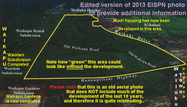
The Pu'unani sub-division would fill in all the open-space between Waikapu town and Wailuku's Kehalani development with about 597 additional housing units plus many potential ohana units.

Pu'unani 2013 EIS Preparation Notice

TMK: (2) 3-5-02:002 and 003 (por.) Permits: State Land Use District Boundary Amendment, County of Maui Community Plan Amendment and Change in Zoning

Applicant: Towne Development of Hawaii, Inc.; Endurance Investments, LLC; and Association of II Wai Hui, LP; PO Box 220, Kihei, HI 96753. Contact: Charles Jencks, 808-879-5205.

Approving Agency: State Land Use Commission, PO Box 2359, Honolulu, HI 96813. Contact: Dan Orodenker, 808-587-3822.

Consultant: Munekiyo & Hiraga, Inc., 305 High Street, Suite 104, Wailuku, HI 96793. Contact: Colleen Suyama, 808-244-2015.
Towne Development of Hawaii, Endurance Investors, LLC and the Association of II Wai 
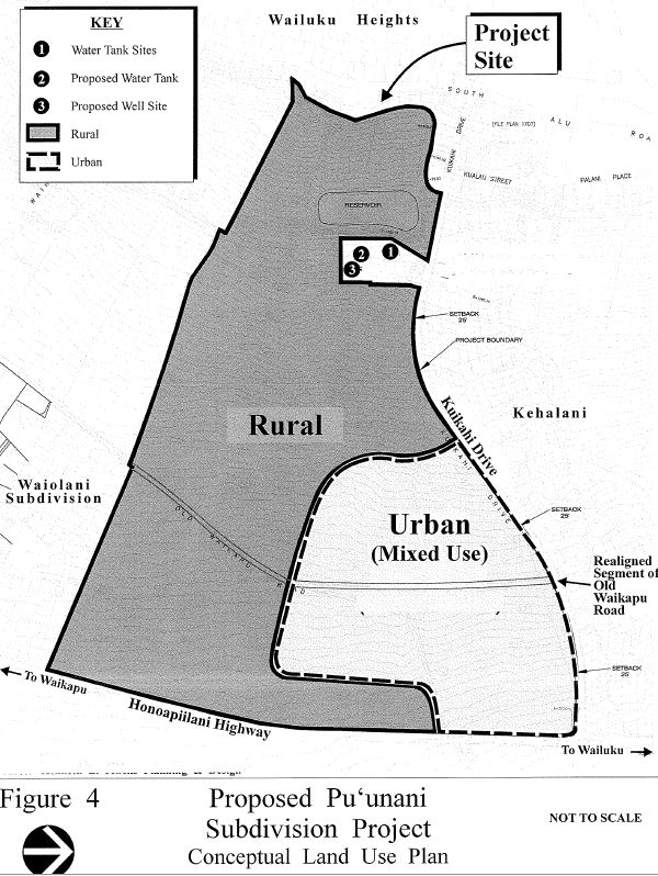
Hui, LP propose the development of the Pu’unani Subdivision Project, consisting of approximately 147 residential lots, a village mixed-use district consisting of approximately 450 multi-family units and approximately 25,000 square feet of commercial retail/office space, and an approximate 15-acre park/stormwater 
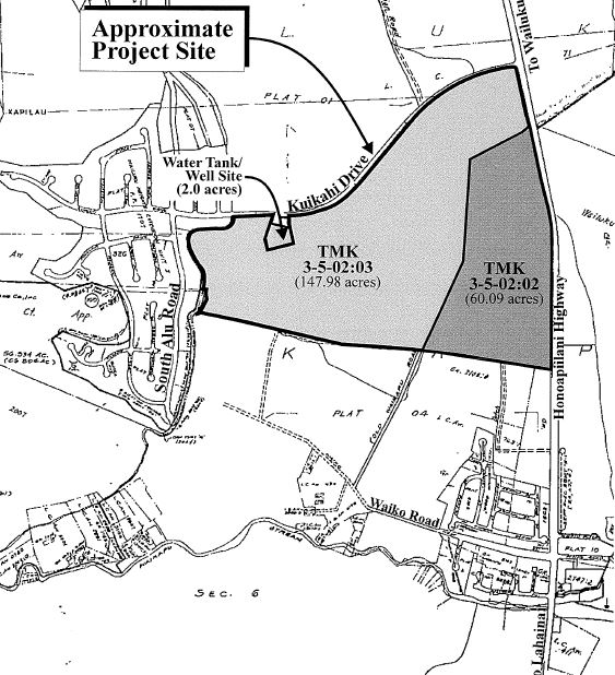
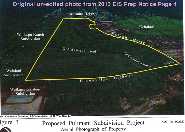
retention area. The project site, consisting of approximately 208 acres, is located in Wailuku, makai of Wailuku Heights and adjacent to the Kehalani master planned community. Related actions include dedicating to the County of Maui, a water storage tank site and development of a new water well for the project adjacent to the County’s existing water storage tank site. The project will include land use amendments including a State Land Use District Boundary Amendment, County of Maui Community Plan Amendment and County Change in Zoning. It will also involve improvement of a government road (Old Waikapu Road) and Honoapiilani Highway to allow for access to the project.
Picture
Picture

Images below are from the 2013 EIS Preparation Notice