Alliance of Maui Community Associations
  • HOME
    • Contact us
  • Communities+Their Associations
    • Direct Links to Community Associations Websites
    • Central Maui Communities >
      • Kahului / Maui Lani
      • Waihee
      • Waikapu
      • Wailuku / Waihehu / Paukukalo
    • East Maui Communities >
      • Hana
      • Keanae / Wailua / Nahiku
      • Kipahulu / Kaupo
    • North Maui Communities >
      • Haiku / Pauwela / Peahi
      • Paia + Spreckelsville
    • South Maui Communities >
      • Kihei / South Maui
      • Maalea
      • Makena
      • Wailea
    • Upcountry Communities >
      • Kula / Keokea / Waiakoa
      • Makawao
      • Olinda
      • Pukalani
    • West Maui Communities >
      • Kaanapali / Napili / Kahana
      • Kapalua / Honoulu
      • Lahaina
    • Maui Organizations - Long List
  • Information
    • County Government >
      • Mayor
      • County Council >
        • Council Members
        • Council Commities
      • County Departments
      • Boards and Commisions
      • Maui County Charter
      • Maui County Code
      • BUS Routes & Schedules
    • State Government >
      • Governor
      • Government Departments
      • Legislature
      • State Boards and Commissions
      • Elections
      • Hawai'i Laws
    • Major Issues >
      • Education
      • Health
      • Disasters >
        • Hurricanes
      • Water >
        • Maui's 3 Watersheds
        • State Water Commission
      • Land
      • Energy
    • MAPS >
      • MAUI ISLAND MAPS >
        • Traditional Hawaiian Land Divisions
        • 19th + 20th Century Maps
        • Modern Maps - Maui Island
        • Maui's Highways + Roads
        • MAUI'S LAND USE DESIGNATIONS >
          • State Land Use Districts
          • County Community Plan Maps
          • County Zoning
          • Entitled and Proposed Developments
        • MAUI'S LAND OWNERSHIP >
          • Map of Large Land Owners
          • Property Tax Maps (TMK's)
          • Real Estate for Sale
      • COMMUNITIES & SUBAREA MAPS >
        • Maui Community Maps
        • Detailed Maps of each Area
        • Mapping Tools (Google, etc.)
        • Census Districts
        • Zip-Code Maps
    • MAUI'S GEOGRAPHY >
      • USGS Topographic Maps
      • Coastline + Beaches + Erosion
      • Waves and Winds
      • Wind Speed Map
      • Solar Radiation
      • Geothermal Potential areas -- Maui County
      • Warm Ground Water Potential -- Maui County
    • DATA and STATISTICS >
      • Hawaii State Data Book
      • Maui County Data Book
      • County Business Patterns
      • Tourism Data
      • Agricultural Data
  • Projects+Developments
    • East Maui
    • Central Maui >
      • Waiale (A&B)
      • Waikapu Town Dev't
      • Nā Wai ʻEhā
      • Waiko Road Industrial Park
      • Maui Lani
      • Kehalani (Stanford Carr)
      • Pu'unani (between Wailuku + Waikapu)
      • Maui Business Park 2
      • Target - Puunene Shopping Center
      • New Kahului Highways and Roads
      • Kahului Airport >
        • Maui Airports - HISTORY
      • A&B's Important Agricultural Lands
    • North Maui
    • South Maui >
      • Makena Resort
      • Honua'ula (Wailea 670)
      • Wailea (A&B)
      • Maui R&T Park
      • Kihei High School
      • Kihei Town Center (Krausz)
      • Former Mega-Malls
      • A&B 600 Unit - North Kihei
    • Upcountry Maui >
      • Haliimaile
      • Kula Ridge
    • West Maui >
      • HOSPITAL -- West Maui
      • Kapalua (Maui Land & Pine)
      • Pulelehua (Maui Land & Pine)
      • Pu'ukoli'i
      • Kaanapali 2020 + Pu'ukoli'i
      • H.H.F.D.C. (North Lahaina)
      • Lahaina Town - South
      • Olowalu Town (Frampton & Ward)
  • Community Plans
    • Maui Island Plan >
      • IMPLEMENTATION CHAPTER
    • Hana (East Maui)
    • Lahaina (West Maui)
    • Kihei / Makena (South Maui)
    • Makawao / Pukalani / Kula (Upcountry)
    • Paia / Haiku (North Maui)
    • Wailuku/Kahului/Waikapu/Waihee (Central Maui))

DISASTERS  and  CIVIL DEFENSE

What are the major natural threats on Maui Island?
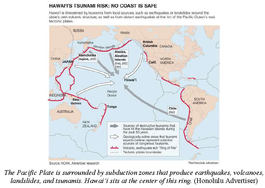
Tsunamis (Tidal Waves), Wild Fires, Hurricanes, Earthquakes, Flash Floods

See the Maui County's website for detailed information:
     Maui County Civil Defense
    270-7285

Disaster Information
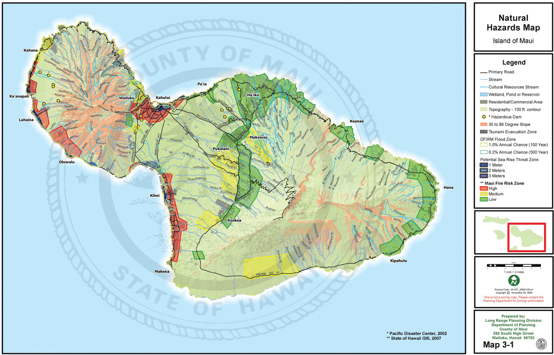
Maui's Natural Hazards
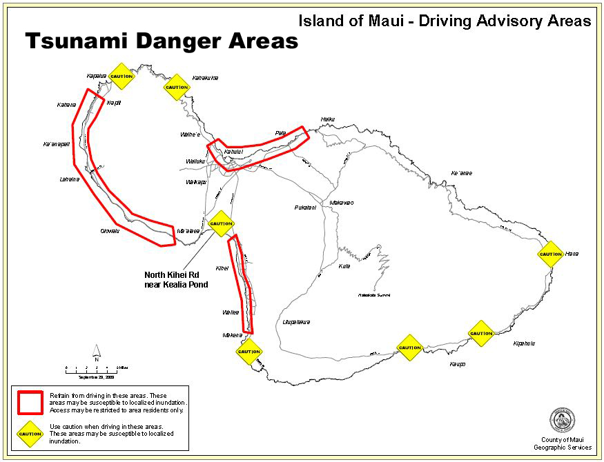
Tsunami Danger Areas
Picture

Flooding in Hawaii

 
Flooding on Maui
Source:  Page 9  http://www.soest.hawaii.edu/coasts/publications/shores/6Streams_and_rockfalls_FLETCHER-final.pdf
 Stream flooding on Maui is not only common, but is the very agent responsible for making it famous as the Valley Island. The deep V-shaped valleys of west Maui have been carved by over one million years of stream flow. Along the eastern half of Maui, the mountains and valleys are much younger and as a result the valleys and streams are not as well developed. Most of the streams cut steeply down to the narrow coastline of Hana, often in cascading waterfalls. Annual rainfall is greatest (360 inches) at the summit of west Maui and nearly as high (280 inches) along the flanks of east Maui just below the trade wind inversion.23 Rainfall tapers off dramatically toward West Maui and Haleakala and is lowest (<15 inches) in the vicinity of Kihei and Lahaina.

Despite the general trend of fewer historic stream floods along the arid south slope of Haleakala and more frequent severe floods in the wetter regions of central Maui, flooding in dry areas such as west and southwest Maui is common. Flooding in areas around Lahaina and Kihei are in part a result of the abrupt transition in slope at the base of the highlands and the behavior of flash flooding. Many historic floods in these two areas occurred after heavy precipitation at higher elevations that fed narrow stream channels, and channelized drainages near the arid coast, to the point of overflow. Flash floods due to heavy precipitation, in some cases equaling the average annual maximum, have occurred throughout the historical record.

During the week of January 14-22, 1990, over twenty inches of rain fell on many parts of Maui causing significant flooding in the coastal zone.24 The north central portion of Maui and the Hana coast, however, have the greatest stream flooding histories. Nearly once a decade, a major flood emanates from Iao Valley bringing sheets of water down into the urban centers of Kahului and Wailuku. Events such as on November 30, 1950, and November 2, 1961, produced enormous volumes of stream discharge out of the Iao Stream Valley and generated sheet flows on the coastal plain below.25 In addition to flooding from stream channels, portions of Maui, notably the Lahaina regions and Kihei, are vulnerable to standing surface water flooding that refuses to drain into the ground.

This may interrupt transportation and damage low elevation buildings. Standing surface water develops after intense rainfall events where poor soil permeability and urbanization prevent adequate drainage. Along the road to Hana, temporary road closures are common due to flash floods and mudslides from the steeper slopes of East Haleakala.
Source:  Page 9  http://www.soest.hawaii.edu/coasts/publications/shores/6Streams_and_rockfalls_FLETCHER-final.pdf