Alliance of Maui Community Associations
  • HOME
    • Contact us
  • Communities+Their Associations
    • Direct Links to Community Associations Websites
    • Central Maui Communities >
      • Kahului / Maui Lani
      • Waihee
      • Waikapu
      • Wailuku / Waihehu / Paukukalo
    • East Maui Communities >
      • Hana
      • Keanae / Wailua / Nahiku
      • Kipahulu / Kaupo
    • North Maui Communities >
      • Haiku / Pauwela / Peahi
      • Paia + Spreckelsville
    • South Maui Communities >
      • Kihei / South Maui
      • Maalea
      • Makena
      • Wailea
    • Upcountry Communities >
      • Kula / Keokea / Waiakoa
      • Makawao
      • Olinda
      • Pukalani
    • West Maui Communities >
      • Kaanapali / Napili / Kahana
      • Kapalua / Honoulu
      • Lahaina
    • Maui Organizations - Long List
  • Information
    • County Government >
      • Mayor
      • County Council >
        • Council Members
        • Council Commities
      • County Departments
      • Boards and Commisions
      • Maui County Charter
      • Maui County Code
      • BUS Routes & Schedules
    • State Government >
      • Governor
      • Government Departments
      • Legislature
      • State Boards and Commissions
      • Elections
      • Hawai'i Laws
    • Major Issues >
      • Education
      • Health
      • Disasters >
        • Hurricanes
      • Water >
        • Maui's 3 Watersheds
        • State Water Commission
      • Land
      • Energy
    • MAPS >
      • MAUI ISLAND MAPS >
        • Traditional Hawaiian Land Divisions
        • 19th + 20th Century Maps
        • Modern Maps - Maui Island
        • Maui's Highways + Roads
        • MAUI'S LAND USE DESIGNATIONS >
          • State Land Use Districts
          • County Community Plan Maps
          • County Zoning
          • Entitled and Proposed Developments
        • MAUI'S LAND OWNERSHIP >
          • Map of Large Land Owners
          • Property Tax Maps (TMK's)
          • Real Estate for Sale
      • COMMUNITIES & SUBAREA MAPS >
        • Maui Community Maps
        • Detailed Maps of each Area
        • Mapping Tools (Google, etc.)
        • Census Districts
        • Zip-Code Maps
    • MAUI'S GEOGRAPHY >
      • USGS Topographic Maps
      • Coastline + Beaches + Erosion
      • Waves and Winds
      • Wind Speed Map
      • Solar Radiation
      • Geothermal Potential areas -- Maui County
      • Warm Ground Water Potential -- Maui County
    • DATA and STATISTICS >
      • Hawaii State Data Book
      • Maui County Data Book
      • County Business Patterns
      • Tourism Data
      • Agricultural Data
  • Projects+Developments
    • East Maui
    • Central Maui >
      • Waiale (A&B)
      • Waikapu Town Dev't
      • Nā Wai ʻEhā
      • Waiko Road Industrial Park
      • Maui Lani
      • Kehalani (Stanford Carr)
      • Pu'unani (between Wailuku + Waikapu)
      • Maui Business Park 2
      • Target - Puunene Shopping Center
      • New Kahului Highways and Roads
      • Kahului Airport >
        • Maui Airports - HISTORY
      • A&B's Important Agricultural Lands
    • North Maui
    • South Maui >
      • Makena Resort
      • Honua'ula (Wailea 670)
      • Wailea (A&B)
      • Maui R&T Park
      • Kihei High School
      • Kihei Town Center (Krausz)
      • Former Mega-Malls
      • A&B 600 Unit - North Kihei
    • Upcountry Maui >
      • Haliimaile
      • Kula Ridge
    • West Maui >
      • HOSPITAL -- West Maui
      • Kapalua (Maui Land & Pine)
      • Pulelehua (Maui Land & Pine)
      • Pu'ukoli'i
      • Kaanapali 2020 + Pu'ukoli'i
      • H.H.F.D.C. (North Lahaina)
      • Lahaina Town - South
      • Olowalu Town (Frampton & Ward)
  • Community Plans
    • Maui Island Plan >
      • IMPLEMENTATION CHAPTER
    • Hana (East Maui)
    • Lahaina (West Maui)
    • Kihei / Makena (South Maui)
    • Makawao / Pukalani / Kula (Upcountry)
    • Paia / Haiku (North Maui)
    • Wailuku/Kahului/Waikapu/Waihee (Central Maui))

A&B's  MAUI BUSINESS PARK  Phase 2 - in Kahului

Final EIS - Maui Business Park Phase 2  (December 2004)
179 acres in two large parcels:
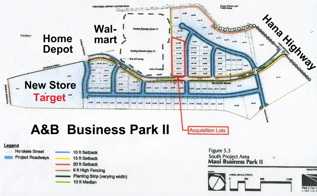
-- A larger one behind Home Depot and Walmart in the direction of the
   Puunene Sugar Mill;  this lot extends out to Hana Highway.
--  A smaller lot on the other side of Hana Highway between the proposed 
     new Airport Access Highway and Costco and KMart.
Target is the first announced tenant, directly behind Home depot.

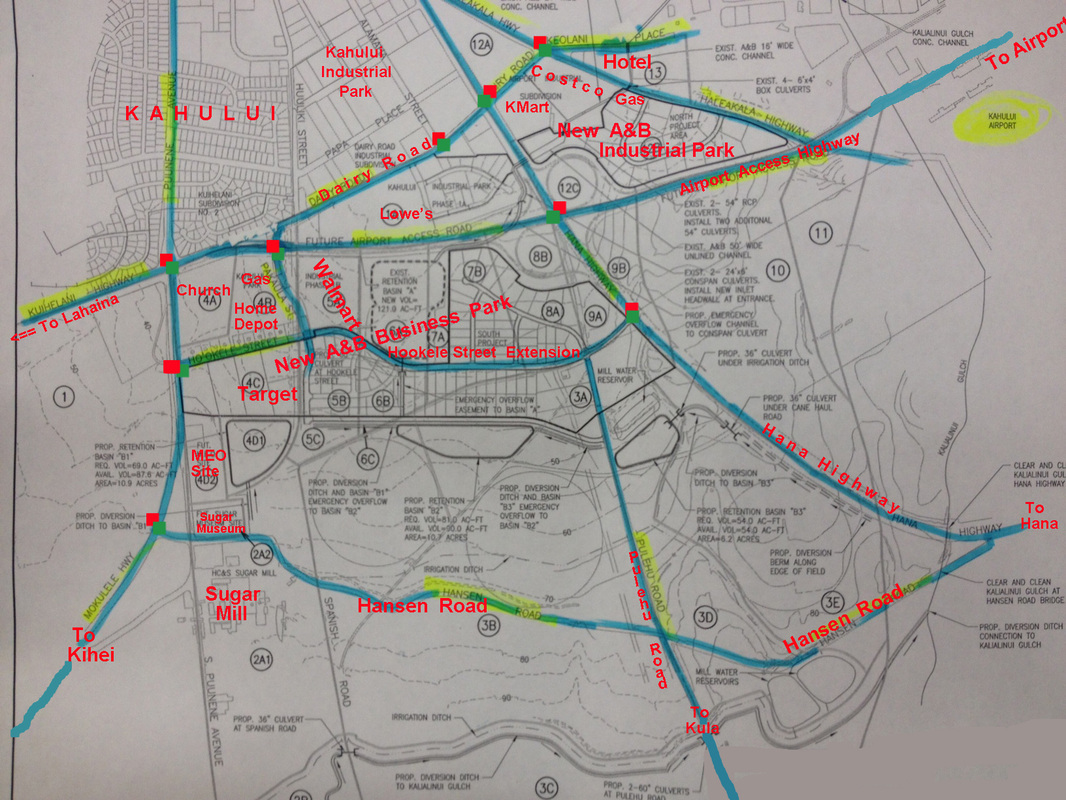
TRANSPORTATION ROUTES:  This map illustrates the many new highways, roads and intersections that are being built in this area: Airport Access Highway, Hookele Street Extension to Hana Highway, the cutting off of Pulehu Road, the bending of Dairy Road into the Airport Bypass near Home Depot, the upgrading of Hansen Road, two new traffic-controlled intersections on Hana Highway, etc.

Picture

The "Acquisition Lots" (in red) is the proposed Maui County Service Center.
Picture
Picture
Location of the two parts of the A&B Business Park Phase II.