Alliance of Maui Community Associations
  • HOME
    • Contact us
  • Communities+Their Associations
    • Direct Links to Community Associations Websites
    • Central Maui Communities >
      • Kahului / Maui Lani
      • Waihee
      • Waikapu
      • Wailuku / Waihehu / Paukukalo
    • East Maui Communities >
      • Hana
      • Keanae / Wailua / Nahiku
      • Kipahulu / Kaupo
    • North Maui Communities >
      • Haiku / Pauwela / Peahi
      • Paia + Spreckelsville
    • South Maui Communities >
      • Kihei / South Maui
      • Maalea
      • Makena
      • Wailea
    • Upcountry Communities >
      • Kula / Keokea / Waiakoa
      • Makawao
      • Olinda
      • Pukalani
    • West Maui Communities >
      • Kaanapali / Napili / Kahana
      • Kapalua / Honoulu
      • Lahaina
    • Maui Organizations - Long List
  • Information
    • County Government >
      • Mayor
      • County Council >
        • Council Members
        • Council Commities
      • County Departments
      • Boards and Commisions
      • Maui County Charter
      • Maui County Code
      • BUS Routes & Schedules
    • State Government >
      • Governor
      • Government Departments
      • Legislature
      • State Boards and Commissions
      • Elections
      • Hawai'i Laws
    • Major Issues >
      • Education
      • Health
      • Disasters >
        • Hurricanes
      • Water >
        • Maui's 3 Watersheds
        • State Water Commission
      • Land
      • Energy
    • MAPS >
      • MAUI ISLAND MAPS >
        • Traditional Hawaiian Land Divisions
        • 19th + 20th Century Maps
        • Modern Maps - Maui Island
        • Maui's Highways + Roads
        • MAUI'S LAND USE DESIGNATIONS >
          • State Land Use Districts
          • County Community Plan Maps
          • County Zoning
          • Entitled and Proposed Developments
        • MAUI'S LAND OWNERSHIP >
          • Map of Large Land Owners
          • Property Tax Maps (TMK's)
          • Real Estate for Sale
      • COMMUNITIES & SUBAREA MAPS >
        • Maui Community Maps
        • Detailed Maps of each Area
        • Mapping Tools (Google, etc.)
        • Census Districts
        • Zip-Code Maps
    • MAUI'S GEOGRAPHY >
      • USGS Topographic Maps
      • Coastline + Beaches + Erosion
      • Waves and Winds
      • Wind Speed Map
      • Solar Radiation
      • Geothermal Potential areas -- Maui County
      • Warm Ground Water Potential -- Maui County
    • DATA and STATISTICS >
      • Hawaii State Data Book
      • Maui County Data Book
      • County Business Patterns
      • Tourism Data
      • Agricultural Data
  • Projects+Developments
    • East Maui
    • Central Maui >
      • Waiale (A&B)
      • Waikapu Town Dev't
      • Nā Wai ʻEhā
      • Waiko Road Industrial Park
      • Maui Lani
      • Kehalani (Stanford Carr)
      • Pu'unani (between Wailuku + Waikapu)
      • Maui Business Park 2
      • Target - Puunene Shopping Center
      • New Kahului Highways and Roads
      • Kahului Airport >
        • Maui Airports - HISTORY
      • A&B's Important Agricultural Lands
    • North Maui
    • South Maui >
      • Makena Resort
      • Honua'ula (Wailea 670)
      • Wailea (A&B)
      • Maui R&T Park
      • Kihei High School
      • Kihei Town Center (Krausz)
      • Former Mega-Malls
      • A&B 600 Unit - North Kihei
    • Upcountry Maui >
      • Haliimaile
      • Kula Ridge
    • West Maui >
      • HOSPITAL -- West Maui
      • Kapalua (Maui Land & Pine)
      • Pulelehua (Maui Land & Pine)
      • Pu'ukoli'i
      • Kaanapali 2020 + Pu'ukoli'i
      • H.H.F.D.C. (North Lahaina)
      • Lahaina Town - South
      • Olowalu Town (Frampton & Ward)
  • Community Plans
    • Maui Island Plan >
      • IMPLEMENTATION CHAPTER
    • Hana (East Maui)
    • Lahaina (West Maui)
    • Kihei / Makena (South Maui)
    • Makawao / Pukalani / Kula (Upcountry)
    • Paia / Haiku (North Maui)
    • Wailuku/Kahului/Waikapu/Waihee (Central Maui))

L A N D    I S S U E S

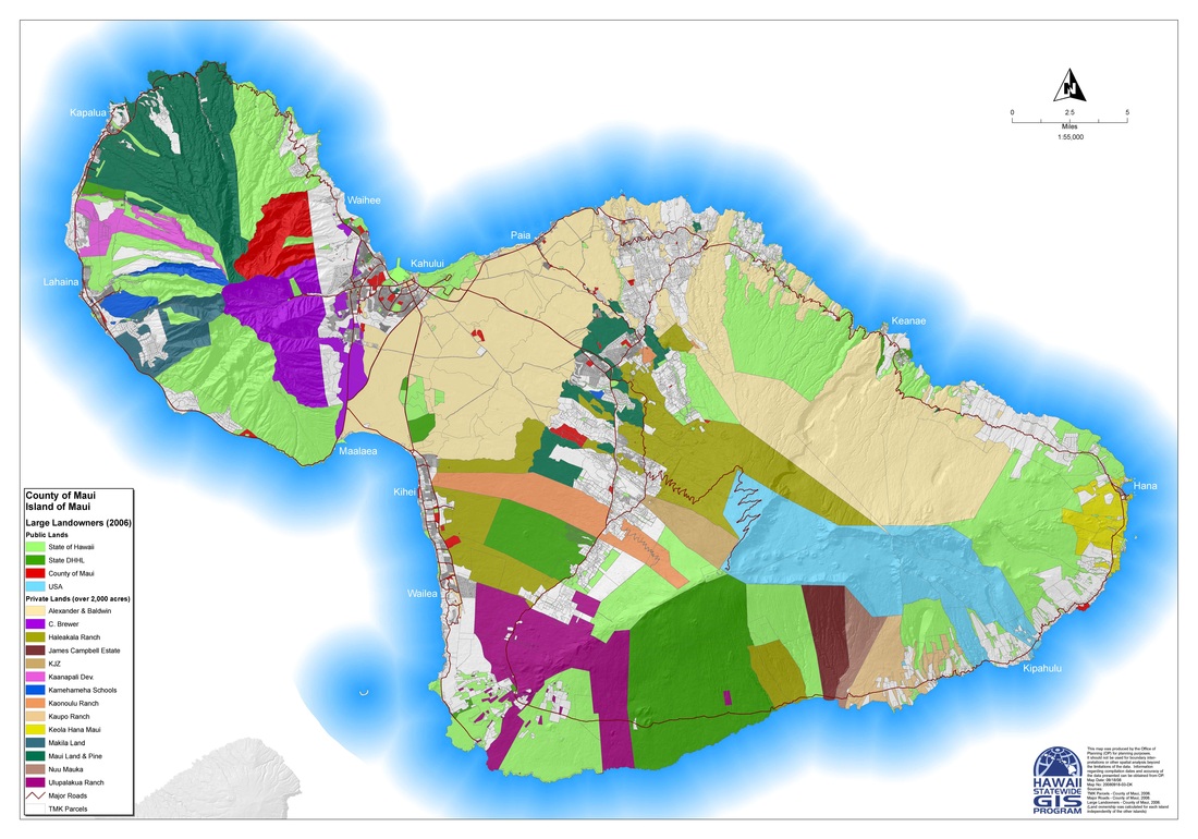
MAP - Maui's State Land Use Districts - 2012 Version  76MB

State_Land_Use_Districts_Maui.pdf
File Size: 3016 kb
File Type: pdf
Download File

Agricultural_Land_Uses_Map_1978.pdf
File Size: 1694 kb
File Type: pdf
Download File

Maui Landownership

Maui Island Plan + Community Plans

State Land Use Commission


State Department of Land and Natural Resources   (DLNR)

  DLNR Divisions                
     Aquatic Resources   (DAR)
     Boating and Ocean Recreation (DOBOR)
     Bureau of Conveyances (BOC)
     Conservation and Resources Enforcement (DOCARE)
     Engineering Division (ENG)
     Forestry and Wildlife (DOFAW)
     Historic Preservation Division (SHPD)
     Hunter Education Program
     Land Division (LAND)
     Office of Conservation and Coastal Lands
     State Parks (SP)