1996 - West Maui Community Plan for
Honolua, Kapalua, Napili, Kahana, Kaanapali, Lahaina, Launiupoko, Olowalu
The Community Plan for the West Maui District is entitled the "West Maui Community Plan". It was adopted by the Maui County Council in 1996 and is due for an update beginning in late 2013 or 2014.
The 1996 Community Plan's TEXT:
http://www.co.maui.hi.us/documents/17/69/240/westmaui.pdf
The 1996 Community Plan's 2 MAPS:
MAP - Kapalua, Pulelehua, Napili, Kahana and Ka'anapali:
http://www.co.maui.hi.us/documents/17/69/73/west%20maui%20cp%201996%201%20of%202.PDF
MAP - Lahaina, Launiupoko and Olowalu:
http://www.co.maui.hi.us/documents/17/69/73/west%20maui%20cp%201996%202%20of%202.PDF
Since 1996 the County Council has made numerous amendments to the maps.
Unfortunately, the County does not post these changes on its website.
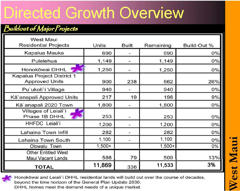
Major Developments and Projects in West Maui
------------------------------------------------------------------------------------------------------------------------------
DEVELOPMENT PROJECT MAPS
The Long-Range Division of the Maui County Planning Department keeps track of developments and projects that have yet-to-be built but which are: a) fully entitled;
b) partially entitled; or c) proposed by a landowner. Here are the developments projects in this district as of February 2011:
MAP - Kapalua, Pulelehua, Napili, Kahana and Kaanapali
MAP - Lahaina, Launiupoko and Olowalu: